B1. Flat map vs Globe
Sunline gives you two ways to look at the Earth.
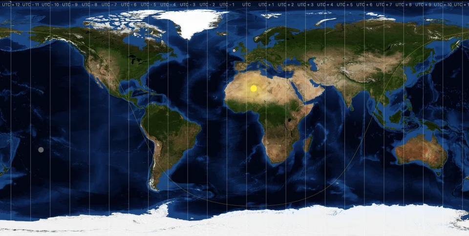
The Flat map is a rectangular projection. You see the whole world at once, the day‑night line drawn as a smooth curve, and the timezone bands as vertical stripes. It's the most efficient view and the best for spotting patterns across continents at a glance. The flat map is the default.
The Globe is a real 3D sphere with shading, light, and clouds wrapped around it. You can rotate it by dragging. It's slower to render than the flat map and the day‑night line becomes a curve around the limb of the planet rather than a line across a rectangle, which can be more intuitive when you want to see who's currently in sunlight.
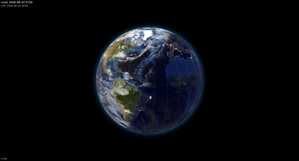
Switch between them in three ways:
- Desktop: press M.
- Touchscreen: tap the map with two fingers at once.
- Or tap the map, then press the Switch View icon in the top‑right controls.
The change is instant, your zoom and centre carry across, and your choice of view is remembered for the next launch.
B2. Gestures, taps, and keyboard shortcuts
On any platform
- Tap or click the map to show/hide the top‑right controls. They hide again after ~4 seconds of inactivity.
- Long‑press a point on the map to set your location there. If the spot can be reverse‑geocoded, your location updates silently; otherwise a small callout appears asking you to type a country and city. See A3. Setting your location.
- Double‑tap to re‑centre the view on your selected location (see below for the globe's extra trick).
- Drag the Clock in the corner to move it (when "Movable Clock" is on — see D2. The Clock overlay).
- Drag the Time-lapse shuttle to speed up or rewind (Premium — see C3. The Time-lapse controls).
- Pinch / scroll wheel to zoom, on both views.
Touchscreen multi‑finger taps
- Two‑finger tap — switch between the flat map and the globe.
- Three‑finger tap — open Settings; another three‑finger tap (on the Settings page) closes it again.
A pinch (fingers that move) is never mistaken for a multi‑finger tap — the tap only fires when the fingers stay put.
Flat map specifics
- Double‑tap re‑centres the map on your selected location — not on the point you tapped.
Globe specifics
- Drag to rotate.
- Double‑tap near a visible pole snaps the globe to a pole‑centred view; a double‑tap anywhere else re‑centres your selected location, as on the flat map.
Desktop keyboard shortcuts
| Key | Action |
|---|---|
| M | Switch view (flat ↔ globe) |
| P | Show / hide the Time-lapse controls (time-lapse only) |
| F11 | Toggle fullscreen |
| Ctrl + ⌘ + F (macOS) | Toggle fullscreen |
| Esc | Exit fullscreen, or close Settings when it's open |
| ⌘ + , (macOS) / Ctrl + , (Windows / Linux) | Open / close Settings (toggle) |
The Settings shortcut is a toggle: press it once to open Settings, again to close it. Esc also closes Settings. Both close it the same way the back / close button does — if you have unsaved changes, you're asked to confirm before discarding them.
These shortcuts are deliberately limited to the actions that the multi‑finger touch gestures cover on mobile.
B3. The Sun line (day / night terminator)
The Sun line — the terminator — is the boundary between the part of the Earth currently lit by the Sun and the part in shadow. Sunline calculates where it is, continuously, from your device's current time and standard astronomy formulas; it isn't a pre‑recorded animation.
It appears as a thin faint line across the map. Show Sun line in Settings → What's Displayed turns it on or off. It's on by default.
The line is independent of the night‑side darkness — you can turn off the line and still see the night, or turn off the night and keep just the line as a marker.
B4. Night side and city lights
The dark hemisphere is shaded so you can see where it's night at a glance. On top of that shading the app overlays NASA's Black Marble city lights — a satellite‑derived image of where the world is brightest at night.
Two settings control this:
- Show Night — the master toggle. When this is off, the night side is no darker than the day side, and city lights are hidden regardless.
- Show Night Lights — toggles the city‑light overlay on or off. Only available when Show Night is on.
Both are on by default.
If you find the night side too dark or too bright relative to the daytime, see the Cloud Tuning panel, which has sliders that affect the night‑side darkness and the brightness of clouds at night.
B5. Cloud cover
Sunline can show real cloud cover over the Earth. There are two layers of capability:
-
All users get a bundled cloud cover image — a representative cloud composite that ships with the app. Toggle it with Show Cloud Cover in Settings → What's Displayed. It's on by default.
-
Premium users can also enable Download Daily Cloud Formations, which fetches a recent satellite cloud composite — Matt Eason's live cloud maps (clouds.matteason.co.uk), derived from EUMETSAT weather‑satellite imagery and refreshed upstream every few hours — and overlays it on the map. The download only happens while you're Live; in time-lapse the bundled demo image is used instead, because there is no "today" to fetch. While you're Live with the toggle on, the app re‑checks for a fresher image at most once every three hours.
The cloud overlay is a mask: white where there are clouds, transparent where there aren't, so the underlying day/night colours show through. Cloud opacity, daytime vs nighttime cloud brightness, and a few other appearance dials live in the Cloud Tuning panel.
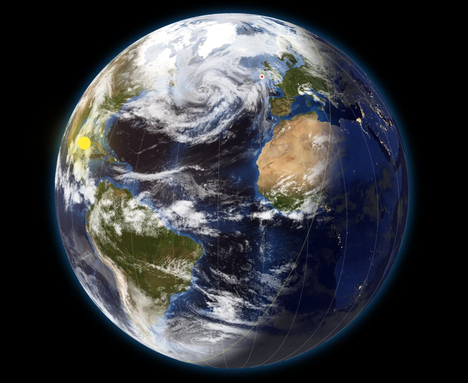
If the download fails (you went offline, the source is unreachable), the app silently falls back to the previously cached image, and if there is no cache, to the bundled demo. You don't lose the cloud layer; it just stops being fresh.
B6. Celestial bodies — sub‑solar and sub‑lunar points
The sub‑solar point is the spot on Earth where the Sun is directly overhead at this instant. The sub‑lunar point is the same idea for the Moon. Together they show you, at a glance, where the Sun and Moon are pointing.
Show Celestial Bodies in Settings → What's Displayed turns these markers on or off. It's on by default. The markers move continuously when Live, and follow the time-lapse clock when you're running one.
You can scale how large these markers appear with the Object Size slider — see D3. Object, Text and Line Size.
B7. Timezones — geographic and political
The world's timezones are a small mess once you start looking. There are three useful ways to slice them:
- The 24 geographic (or "nautical") timezones — one for every 15° band of longitude. They are astronomically tidy and don't change with politics.
- The ~39 standard‑offset zones — what you get if you take the IANA database and group every region by its standard UTC offset (ignoring daylight saving). 24 of these correspond to the geographic bands; the other ~15 cover the half‑hour and quarter‑hour offsets like UTC+05:30 (India), UTC+05:45 (Nepal), or UTC+09:30 (Northern Territory).
- The ~340 political timezones themselves, each managed by a national government (e.g.
Europe/Dublin,America/New_York). These are what your phone uses to compute local time. A single political timezone likeEurope/Dublinflips between Irish Standard Time (UTC+01:00) in summer and Greenwich Mean Time (UTC+00:00) in winter.
Sunline draws two of these on the map:
Geographic timezones are the 24 evenly‑spaced bands of longitude, each 15° wide — drawn as faint pole‑to‑pole vertical lines. They're the simplified, astronomically tidy view of how the world is divided by the Sun. Show Geographic Timezones toggles them on or off. On by default.
Political timezones (Premium) are the real, jagged boundaries countries actually use. Sunline groups the ~340 IANA timezones by their standard UTC offset, dissolves them into per‑offset regions, and draws their outlines. The result is a clean, country‑accurate set of zone shapes that includes the half‑hour and quarter‑hour offsets. Show Political Timezones is off by default. The boundary data isn't bundled with the app — it's a small download (well under a megabyte) fetched the first time you can use it, which also means boundary corrections can reach you without an app update. On mobile, turning the layer on shows a brief notice that drawing these boundaries on the CPU may cost extra battery.
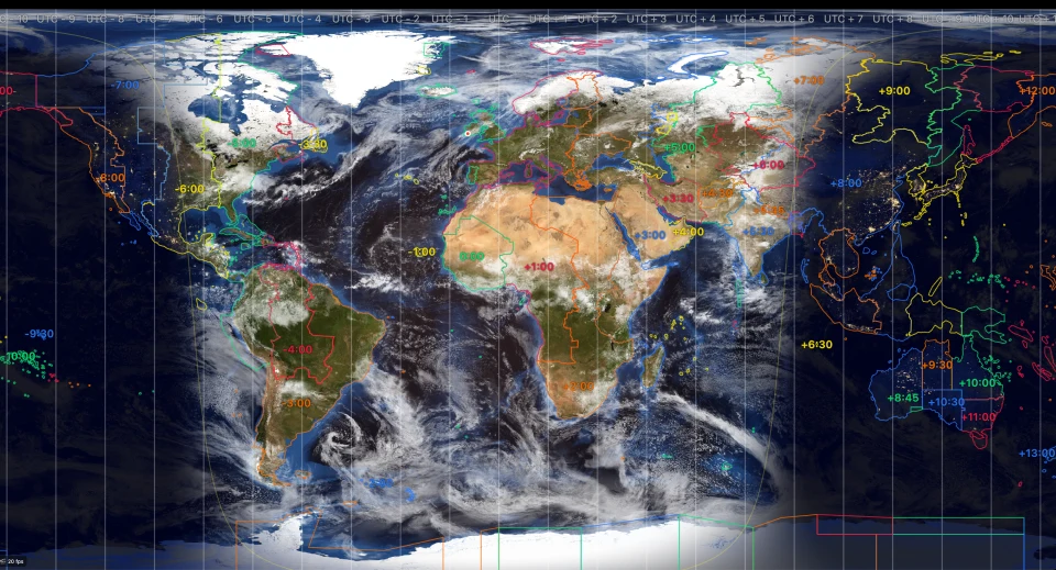
The two are independent — you can show either, both, or neither. The clock overlay uses the IANA timezone of your selected city (not a slice of longitude), so it always shows the correct legal local time including DST.
B8. The location marker and label
A small marker pins your selected city on the map, with the city and country name printed beside it.
- Show Location toggles the marker (and its label) on or off. On by default.
- Show Location Label toggles just the text. Only enabled when Show Location is on. On by default.
If you've turned on Center Map on Location (see D4), the map keeps your location in the middle of the view. If you've turned it off, you can scroll or rotate the world freely and the marker just sits at the right latitude / longitude.
B9. Seasonal maps
(Premium) The Earth doesn't look the same in January as in July — the Sahara expands, the Arctic ice cap retreats, the northern forests turn green. Sunline can switch between twelve monthly textures (NASA Blue Marble) and use the texture that matches the current month, or the month in your time-lapse.
Show Seasonal Maps in Settings → What's Displayed turns this on. It's off by default. Without it, a single neutral Earth texture is used year‑round. The switch takes effect immediately — the map re‑textures for the current month as soon as you toggle it.
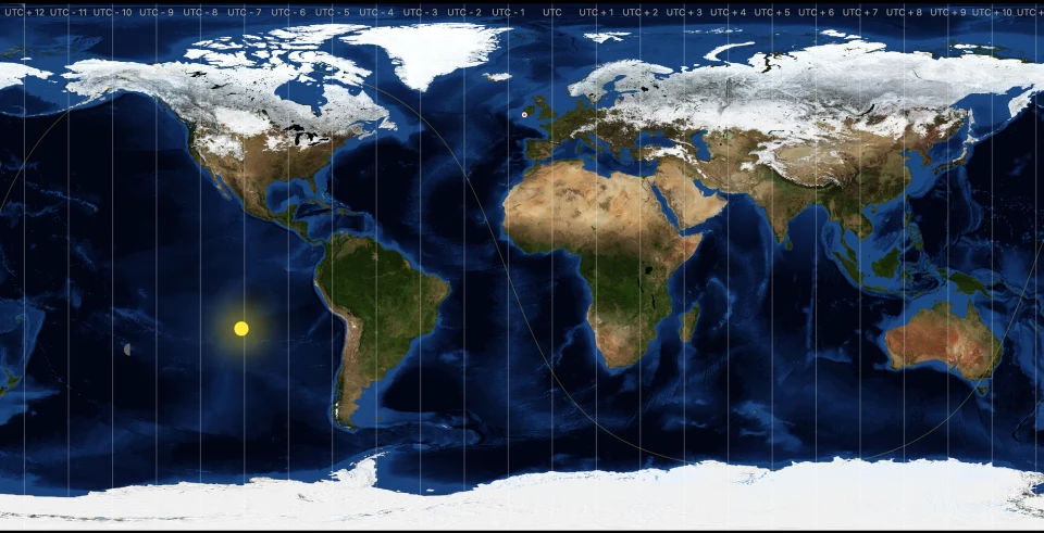
There's a related setting in the Advanced tab — Allow Zoom Seasonal maps when in Simulation mode — which controls whether the seasonal textures are also loaded and used at higher zoom levels while you're scrubbing through time. This is off by default because loading and switching seasonal textures while zoomed is more demanding.